Sunday, 22 March 2020

Gulf Harbour

Our last stop up north, before passing through Auckland, was Gulf Harbour. We have a lot of friends here from the time we lived in Fairway Bay Marina, so as we were 'passing', wanted to take the opportunity to stop and say hi. Who knows when we'll be back up this way! Sadly, with the Covid-19 (Corona virus) wrecking its own flavour of havoc, (causing isolation and restricted group gatherings), plus being short on time, we missed a few of them.

The photo above shows the entrance to the marinas and that's one of the ferries on the left (yellow)  berthed and taking on passengers.

We stayed in the Gulf Harbour car park. This is the same piece of grass as in the previous photo, just turned about 90 degrees. The ferry is to my right, entrance to the marina directly behind me and to the left ... the sea.

The view from the slide-out window in our rig. That's the entrance to the marina to the left of the tree.

A stunning day — perfect to be out on the water. We're not sure about this poor cruise ship out in the harbour  they were there when we arrived and still there when we left. I expect they cannot dock because of the Covid-19 restrictions at present.

Meanwhile, yachties make the most of the fabulous weather. Auckland City is in the background.

And this is one of the ferries, arriving from Auckland. You can see SkyTower behind them.

More people enjoying the water. 

Coming out of the marina ... 

A beautiful sunset to finish off a lovely day.


If you cannot see "Post a Comment" below, click here (and scroll down to the bottom of the post) to talk to me! 

Friday, 20 March 2020

Tokerau Beach


Yes, we're finally back on the road! We left Fairway Bay Marina in December and spent Christmas with family in Taranaki. Then after a brief spell at Bell Block, near New Plymouth, and a quick trip down to Wanganui, we headed north. 

We had a great stay with friends at Ruakaka, and then moved on to spend some time in Kerikeri with family. Next stop was Tokerau Beach ... a beautiful spot up on the Karikari Peninsula. We stayed in an NZMCA Park which was about a five-minute walk from the beach.

Looking south down the beach. Over the bay, way in the distance, is Coopers Beach.

 Tokerau Beach is a really long beach looking out into Doubtless Bay — this photo is taken with the tide out. The beach seems very flat, and when the tide's in, the water is right up close to the dunes. There's not a lot of soft sand like you'd find at the top of many beaches.

We were at Tokerau Beach for five days, and the whole time it was really windy. These terns were part of a large mob all huddled on the beach, facing into the wind. 

The beach is also a road  obviously only when the tide's out — and the occasional vehicle whizzes by ... and 4WD bikes as well.

When we walked to the beach, we were near the north end. Those white spots near the water on the right are terns.

When the tide's in, this rocky section is inaccessible.

The rock strata here is really interesting. 


Here's where we stayed. I'm taking the photo from the corner of the park just after we'd come back through the gate from the beach. Most of the people were parked up to our right (out of the photo). As you can see, we had no close neighbours — there's plenty of room!

We would have liked to have stayed longer, but with it being so dry up in the Far North, there were major water restrictions. The normal place a camper could fill up with water was not available, so we had to leave and travel back down the island until we could find water.


If you cannot see "Post a Comment" below, click here (and scroll down to the bottom of the post) to talk to me! 

Saturday, 4 January 2020

Tongaporutu - The Three Sisters

Tongaporutu is a small place 15km south of Mokau, about 68km north of New Plymouth. It's situated at the mouth of the Tongaporutu River, just off State Highway 3. As you travel along the highway, this is the view if you look to the east towards the sea as you cross the bridge.

There's a great free camping spot where you can stay for three days if you're fully self-contained. We're near the end; there's more parking space on the left side of the photo, closer to the river.

 At low tide, you can walk along the black sand towards the river mouth, then along the beach towards "The Three Sisters". It's an easy walk but can be slippery in places, especially alongside the river. I wore sneakers, but when you get to the beach, there are a lot of places where water flows from the land down to the sea and to get past those, you might need to get your feet wet.

The cliffs along here consist of grey papa and sandstone. The action of the ocean is consistently shaping and eating away at the coastline. I read that it's believed to be eroding at the rate of two metres annually.

One of the first rock formations we came to had an interesting carving of a face on it. 

Looking back at this huge rock, you can see how the sea and weather have created caves and tunnels.

Looking past the rock, the landform you can see in the background is actually on the other side of the river mouth. The effect of the sea is obvious here as well with caves clearly visible.

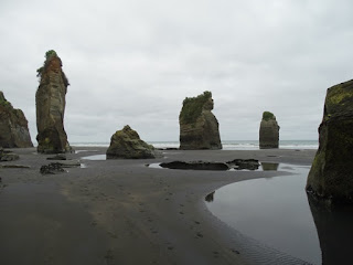
Eventually, we arrived at The Three Sisters, or what is now "The Two Sisters" since the sea claimed one of them. In the distance to the left is what's left of Elephant Rock you can make out the two legs and back of the elephant, but it lost it's trunk to erosion in 2016.

We've travelled past Tongaporutu for years, and this is the first time we've stopped to have a look. It's so easy to be 'too busy' and miss out on experiencing this beautiful area. Twenty years ago there were apparently four sisters! So if you want to see these, take the time to stop before the sea claims them all. Having said that, in the photo above, you can see another pillar to the left, so who knows what the sea will carve out of the landscape over the next twenty years.

This, I believe, is one of the original Three Sisters with the top shaped to look like a face. She currently provides a home for nesting white-fronted terns. (I think that's what they are!) They're the white dots halfway up.


A closer view ... Mumma tern and her chick are safe from humans with their nest way up here.

Here's a closer look at the coastline on the other side of the river mouth. During high tide, most of these caves would be underwater.

On our way back, we stopped to chat with Gavin, our motorhome neighbour. You never know who you're going to come across while travelling ... we knew Gavin and Vicki when we lived in Stratford about 20 years ago. Although no fish were caught today, I understand kahawai have been in the past.

Walking back along the side of the river. This walk is not possible at high tide, so you need to time your visit to make sure you can access the beach and have long enough to see what you want to without getting caught by the incoming tide. It's only about a 15-minute walk to the rock formations, and the coastline all along the way is well worth seeing.

On the day we left, I took this photo as we drove over the bridge. You can see where the campers park on the right side of the photo.


If you cannot see "Post a Comment" below and want to talk to me, click here (and scroll down to the bottom of the post).